Placenames & Maps
Placenames are a vital part of our heritage. They preserve
folklore, geography, history and tradition. The vast majority of the placenames
of our parish are Gaelic in origin and were given to the various localities by
our ancestors in the dim and distant past. Each place name had a special meaning
and their roots often go deep in history. It is an absorbing and rewarding task
to study and explain them and even the name of the smallest patch of ground or
boreen or hill or stream is worth preserving and recording not alone for
ourselves but for the benefit and enlightenment of generations to come. Some of
the words in Gaeilge have become grossly corrupted in the course of time by
Anglicisation, by erroneous spelling and by faulty pronunciation while many of
them were never written down but passed from mouth to ear down the generations.
The old townlands were often divided into quarters which were generally
distinguished from one another by adjectives describing size, position, shape or
quality of the land or by adding the names of the occupiers (PW Joyce Irish
names of Places, Vol. 1 Page 244 published Dublin 1869).
There is evidence of this in our parish where there are 36
townlands in all – 34 distinct townlands with Clonee divided into Clonee East
and West while Ullard is divided into Ullard More and Ullard Beg. The reader
will also notice from the table below how the occupiers of various portions of
land may have given the townsland its name e.g. ‘Cappawater’ – ‘Walton’s plot of
land’ or ‘Clonee’ – ‘Hugh’s meadow’. Depending on the date and circumstances in
some cases the landowners had sufficient influence with Government officials to
have their own names substituted for the ancient ones. Some townlands have been
submerged into adjoining townlands and examples of these in our parish are
Tinnmogney (House of Mogney) which has been absorbed into Myshall itself and
Killeavy (Church of the Mountain View) which is situated in Shangarry though
that name is still attached to a field and sometimes the crossroads otherwise
known as ‘Doyle’s Cross’.
The meanings and Irish translations given in this article are all taken from a book called ‘Place Names of County Carlow’ written by Edward O’Toole 1937. The extra meanings denoted by an asterisk are ones that have been used by locals and have come to the attention of the Magazine committee.
Edward O’Toole was from Rathvilly and in the course of historical research he studied ‘Name Books’ which were preserved in the Ordnance Survey Department in the Phoenix Park. This list is not exhaustible and inevitably there has to be a measure of conjecture but everyone interested has a right to be heard. Hopefully this article will lead to discussion and perhaps the recording not only of the townlands but also of the various field names, bridges, gaps, hillocks, streams etc. before they are lost forever.
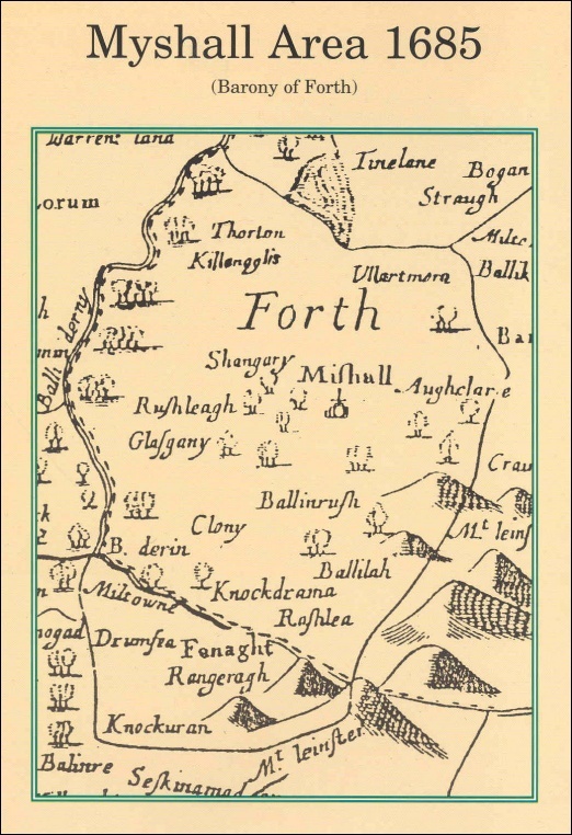
The study of ancient maps also provide a wealth of knowledge on the names of places and how they have changed over the years. Myshall village itself does not exist on the map prepared in the year 1570 for Sir Peter Carew though Drumphea that is now part of the parish is marked spelled ‘Drumffey’. Myshall is clearly marked on the map of Sir William Petty of 1685 as are many other of the townslands as we know them today though the spelling is somewhat corrupt e.g. Turtane is spelled Thorton, Kilmaglush - Killengglis, Clonee - Clony, Bealalaw - Ballilah, Rathnageeragh - Rangeragh, etc.
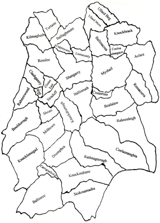
| Townsland | Irish Translation | Meaning |
| Aclare | Ath Cláir | Ford of the Board or Plank |
| Ballaghmore | Bealach Mór | Great Road or Pass |
| Ballinacrea | Baile na Cré | Town of the Clay *home of the Trees* |
| Ballinree | Baile an Rí | Home of the King |
| Ballinrush | Baile an Ruis | Town of the Wood |
| Bealalaw | Béal a Lagha | Mouth or gorge of the Hill *Ford of the Round Hill* |
| Booldurragh | Buaile Dorcha | Dark Booley (Milking Place) or Mountain Dairy *Black Marsh* |
| Cappawater | CeapaBhaiteir | Walton's Plot of Land |
| Carrignafecka | Carraig na Feice | Rock of the Fack *Rock of the Raven/Tooth shaped rock* |
| Clashganny | Clais Gainimhe | Sand Pit |
| Clonee (East) (West) | Cluain Aodha | Hugh's Meadow or Lawn |
| Coolasnaughta | Cúl a tSneachta | Back of the Snow *Hill back of the Snow* |
| Coolnasheegan | Cúl na Siogan | Corner of Crows/ frequented by birds *Back of the Fairy Mounds* |
| Croanruss | Crón Ros | Brown Wood |
| Drumphea | Droim Feidh | Ridge of the Wood *Steep Ridge of the Ravens*/*Deer* |
| Kilmaglush | Cill Maige Glaise | Church of the Green Plain *Wood of the Stream* |
| Knockbrack | Cnoc Breac | Speckled Hill |
| Knockdrumagh | Cnoc Druimeach | Hill of the Ridges or Backs *Hill of the thieves* |
| Knockindrane | Cnocán Draoighin | Hill of the Blackthorns or Sloe Bushes |
| Knocklonogad | Cnoc Cluana Gad | Hill of the Lawn of Gads or witches *Hill of the Marsh of witches/robbers* |
| Lismaconly | Leas Nic Conghaile | McConly's Fort *Fort of Connolly* |
| Milltown | Baile a Miuilin | Town of the Mill |
| Myshall | Maigh Íseal | Low Plain |
| Raheenleigh | Raitín Liath | Grey Little Rath *Little Grey Forts/ Little Grey Wood* |
| Raheenwood | Coill Raitín | Wood of the Raheen or Small Earthen Fort *Little Fort of Wood* |
| Rathnageeragh | Rath na gCaorac | Fort of the Sheep |
| Rossacurra | Ros a Cuiraigh | Wood of the Moor *Wood of the Weir/Barony of Faith* |
| Roslee | Ros Liath | Grey Little Fort *Grey Peninsula* |
| Seskinamadra | Seiscin na Madra | Sedgy Marsh of the dogs or foxes |
| Shangarry | Sean-garraidh | Old Garden |
| Shean | Siodhan | A Fairy Mount |
| Straduff | Srath Dubh | Black Strath or Holm *Black Meadow Land (with turf)* |
| Turtane | Tuartán | A hillock/isolated bank *High Bank* |
| Ullard More | Abhall Gort | Big Apple Garden/Orchard |
| Ullard Beg | Abhall Gort | Small Apple Garden/Orchard |
1685 Map Of Myshall: