
Attractions
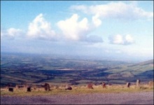
MOUNT LEINSTER, SUIDHE LAIGHEAN
Meeting Place of the Men of Leinster
The 2,610 feet summit is crowned with a sepulchral cairn (buried site) dating from the first century of the Christian era and marking the grace of the Cucorb King of Leinster who was slain in battle at the foot of the mountain by Fedhlimidh Reachtmhar, King of Ireland, who was himself slain in 199 A.D. Tradition holds with the theory that when a king or chieftain was killed he should be buried at the highest point of land in the area.
The television mast which now acts as a landmark was erected in 1960.
Nearby Sliabh Ban has a smaller cairn and stone chamber and marks
another grave from early Christian times.
NINE STONES, SLIEVEBAWN
 The true origin of a famous landmark known as “The Nine Stones” is
lost in antiquity. The stones are probably of the early or pre-Christian
era when nine was a mystical number being a trinity of trinities etc.,
but varying traditions mark it as: the final resting place of nine
chieftains; a place where nine rebels were killed; the burial place of
1798 heroes killed by Yoemen returning from the battle of Newtownbarry
(Bunclody); or the burial place of nine shepherds. A custom in the old
days was for those passing to place a small stone on the graves of those
buried there.
The true origin of a famous landmark known as “The Nine Stones” is
lost in antiquity. The stones are probably of the early or pre-Christian
era when nine was a mystical number being a trinity of trinities etc.,
but varying traditions mark it as: the final resting place of nine
chieftains; a place where nine rebels were killed; the burial place of
1798 heroes killed by Yoemen returning from the battle of Newtownbarry
(Bunclody); or the burial place of nine shepherds. A custom in the old
days was for those passing to place a small stone on the graves of those
buried there.
![]()
ST. FINIAN'S CHURCH, MYSHALL
 The area was originally evangelised in the 5th century by St.
Foirtcheirn, a grandson to Lasire High King of Ireland at the time of
St. Patrick. Foirtcheirn had been Bishop of Trim, Co. Meath but left his
See to take part in the conversion of the country. A ruined pre-Norman
church, called after St. Finian b. 454, a student of Foirtcheirn,
stands almost opposite the Catholic Church of the Holy Cross. Finian
known as “The tutor of the Saints of Ireland” was a native of the
townsland of Rossacurra near Myshall.
Later an angel led Finian to a spot beside the river Boyne, Clonard, Co.
Meath where he founded one of the “greatest schools in Ireland” and
where he died about the middle of the sixth century. But Myshall
remembers her son with pride and honours him as one of the famous men of
Ireland.
The area was originally evangelised in the 5th century by St.
Foirtcheirn, a grandson to Lasire High King of Ireland at the time of
St. Patrick. Foirtcheirn had been Bishop of Trim, Co. Meath but left his
See to take part in the conversion of the country. A ruined pre-Norman
church, called after St. Finian b. 454, a student of Foirtcheirn,
stands almost opposite the Catholic Church of the Holy Cross. Finian
known as “The tutor of the Saints of Ireland” was a native of the
townsland of Rossacurra near Myshall.
Later an angel led Finian to a spot beside the river Boyne, Clonard, Co.
Meath where he founded one of the “greatest schools in Ireland” and
where he died about the middle of the sixth century. But Myshall
remembers her son with pride and honours him as one of the famous men of
Ireland.
![]()
TOBAR BHRÍDE, MYSHALL
 A small amenity park in the village contains a Water Wheel, a bullaun
stone and a holy well dedicated to St. Brigid after whom the park is
called.
A small amenity park in the village contains a Water Wheel, a bullaun
stone and a holy well dedicated to St. Brigid after whom the park is
called.
There are no known traditions of cures or pilgrimages associated with the well but a patron (pattern) was held annually here on the 14th day of September – the feast of the Holy Cross – titular feast of Myshall. A sheep fair was held on this date up to the 1960’s.
![]()
VILLAGE PUMP, MYSHALL
 The pump takes centre stage in the village. Old photographs of the
village clearly indicate the presence of the pump at the turn of the
century. At first it was used for domestic purposes – the water drawn
from it in buckets and cans and there would no doubt have
been a drinking trough for horses present.
The pump takes centre stage in the village. Old photographs of the
village clearly indicate the presence of the pump at the turn of the
century. At first it was used for domestic purposes – the water drawn
from it in buckets and cans and there would no doubt have
been a drinking trough for horses present.
It was probably around the village pump that Charles Stewart Parnell made a speech when he came to the village fighting the Carlow By-Election of 1891.
![]()
BYRNE MEMORIAL MILLENNIUM PARK
 The millennium committee was conscious of honouring the parish’s greatest
benefactor Dr. Joseph Byrne and the opportunity presented itself in the year
2000 when the area inside what is known as “The Grand Gates” leading to “The
Lawn” was completely transformed from a swampy over-grown area into an amenity
park. Possibly one of the most spectacular thunderstorms of the millennium
provided the background for the opening of the Park
The millennium committee was conscious of honouring the parish’s greatest
benefactor Dr. Joseph Byrne and the opportunity presented itself in the year
2000 when the area inside what is known as “The Grand Gates” leading to “The
Lawn” was completely transformed from a swampy over-grown area into an amenity
park. Possibly one of the most spectacular thunderstorms of the millennium
provided the background for the opening of the Park
![]()
THE CROPPY ROAD AND 1798 ACTIVITIES IN THE AREA
 The first mile of the road which leads from the village to Borris is
known as the Croppy Road and got its name from the 1798 troubled period
of Irish history. Myshall at the time was governed by the local landlord
Major Cornwall who was the military officer and magistrate for the
district. There were a number of locals in the movement known as the
United Irishmen, with Captain James Nolan as their leader, who took part
in the battles of Borris returning to Myshall unharmed.
The first mile of the road which leads from the village to Borris is
known as the Croppy Road and got its name from the 1798 troubled period
of Irish history. Myshall at the time was governed by the local landlord
Major Cornwall who was the military officer and magistrate for the
district. There were a number of locals in the movement known as the
United Irishmen, with Captain James Nolan as their leader, who took part
in the battles of Borris returning to Myshall unharmed.
![]()
RATHNAGEERAGH CASTLE (Fort of the Sheep)
Situated at the foot of one of the slopes of Mount Leinster, Rathnageeragh Castle bears every evidence of having been a place of considerable extent and great strength. The remains consist of a square gatehouse of two storey's. An entrance leads to a central vaulted passageway between two parallel vaulted chambers. A courtyard is visible as a slightly raised platform at the southwest. It was originally built as an out fort by the Kavanagh family until 1631. The castle was destroyed by Cromwell in 1650. The gun platform used to bombard the building can still be seen on a hill in the neighbouring townsland.

Ruin of the 13th century Rathnageeragh Castle
Following the Wells Inquisition the Castle and much of its surrounding lands
were given to Sir Richard Kennedy. In the last century a set of manacles and
fetters were found in the castle walls – they were unique as they were thought
to be of Gallic rather than Norman origin. A cannon ball is in the possession of
Mr. Michael Slye, Coolasnaughta.
ROCK ART, KNOCKBRACK
 There are a couple of examples of Rock Art dating from the early
Bronze Age in the area. A granite boulder at Knockbrack shows a large
rayed and circled cup mark surrounded by 12 smaller cup marks. It is dated
circa 500 B.C. and bears similarity to many others found in Britain and
north France. A triangular example of Rock Art is in the possession of Mr.
Michael Slye, Coolasnaughta and bears shallow decorations including at
least four cups and circles, two X’s and several cup marks.
There are a couple of examples of Rock Art dating from the early
Bronze Age in the area. A granite boulder at Knockbrack shows a large
rayed and circled cup mark surrounded by 12 smaller cup marks. It is dated
circa 500 B.C. and bears similarity to many others found in Britain and
north France. A triangular example of Rock Art is in the possession of Mr.
Michael Slye, Coolasnaughta and bears shallow decorations including at
least four cups and circles, two X’s and several cup marks.
![]()
ST. MOLING’S CEMETERY, BALLINREE
 The interior of the ruins consist of a stoned building approx. 20
feet by 8 feet by 2 feet high and are called after celebrated St. Moling
who is buried in St. Mullins about 20 miles south of here. The ruined
building would seem to suggest a type of oratory and would indicate a
hermitage rather than a monastic settlement. St. Moling was a seventh
century Saint whose life was well documented. His greatest feat was the
remission of the Borumean Tribute which was a tax levied for five
hundred years by the High Kings of Ireland on the people of Leinster and had to
be paid every second year.
The interior of the ruins consist of a stoned building approx. 20
feet by 8 feet by 2 feet high and are called after celebrated St. Moling
who is buried in St. Mullins about 20 miles south of here. The ruined
building would seem to suggest a type of oratory and would indicate a
hermitage rather than a monastic settlement. St. Moling was a seventh
century Saint whose life was well documented. His greatest feat was the
remission of the Borumean Tribute which was a tax levied for five
hundred years by the High Kings of Ireland on the people of Leinster and had to
be paid every second year.
![]()
GARRYHILL – GARBH COILLE – Rough Wood
Garryhill was the ancient stronghold of the 14th century figure, Art Óg Kavanagh, King of Leinster, who described by the Four Masters as “a man who defended his throne against the English and the Irish from the age of sixteen years to his sixtieth year”. According to local tradition the castle was situated adjacent to what is now Garryhill House which, owned by Lord Bessborough in the 18th century, served as the residence of the Earl’s eldest son Viscount Duncannon.
![]()